


| Detail | Information |
|---|---|
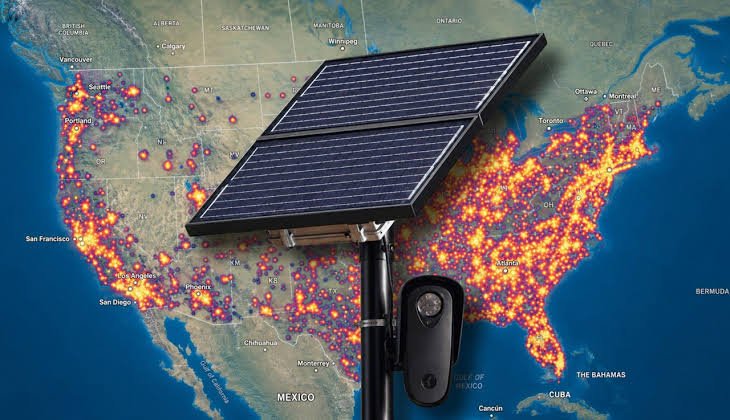
| What is it? | A map showing Flock and other ALPR camera locations |
| Main technology | Automated License Plate Recognition (ALPR) |
| Company | Flock Safety |
| Primary use | Vehicle identification and public-safety investigations |
| Typical data captured | Plate image, vehicle details, time, and camera location |
| Official nationwide map | No single public map has been provided |
| Public alternatives | Community and OpenStreetMap-based projects |
| Location coverage | Primarily the United States |
| Data accuracy | Varies by map and local reporting |
| Privacy concern | Camera networks can reveal vehicle movements |
What Is the Flock Camera Map?
A Flock camera map shows known locations of Flock Safety cameras. These cameras are automated license plate readers, commonly called ALPRs.
They photograph passing vehicles and record several vehicle details. Flock says its ALPR system captures license plate images, vehicle characteristics, timestamps, and camera locations.
The map itself is not usually operated by Flock Safety. Several independent projects publish camera locations using public or community-sourced information.
This distinction matters when checking accuracy.
Why People Search for Flock Camera Locations
Interest in Flock cameras has grown with their wider deployment. People often want to know whether cameras exist along familiar roads.
There are several practical reasons for checking a map:
- Finding cameras near a neighborhood
- Understanding local surveillance infrastructure
- Checking publicly documented camera locations
- Researching ALPR deployment
- Learning about privacy and data retention
- Comparing local camera coverage
A map can provide useful context. However, it cannot prove that every camera has been identified.
How to Find Flock Cameras Near You
Several independent websites currently provide searchable maps.
Community-Based Flock Maps
Flock Locations publishes a community-maintained Flock camera map. Its data comes from user reports, and its verified dataset requires confirmation from multiple observers.
Another option is Flock Camera Locations. It uses OpenStreetMap-based camera information and provides location searches across many areas. The site clearly states that its coverage can be incomplete.
These maps are useful research tools. They should not be treated as official government records.
OpenStreetMap-Based Mapping
OpenStreetMap has become important for documenting ALPR infrastructure. Community contributors can record camera locations observed from public areas.
Some independent maps then use that information. This creates a useful public resource without requiring a single nationwide government database.
However, coverage depends on local contributors. A missing marker does not necessarily mean there is no camera.
What Information Does a Flock Camera Capture?
Flock Safety describes its system as vehicle-focused rather than facial recognition technology.
According to the company’s privacy information, its ALPR system collects:
- License plate images
- Vehicle characteristics
- Date and time information
- Camera location
Flock says the system does not collect facial recognition data or biometric information through its ALPR technology.
The distinction is important. A camera can avoid facial recognition while still creating records about vehicle movements.
How Long Is Flock Camera Data Stored?
Data retention depends partly on the local agency and applicable law.
Flock says images and footage are automatically deleted after a set period. Its current privacy information says 30 days is common, unless local requirements establish another period.
Access is also controlled through the customer agency.
Flock says searches are logged for later review. This creates an audit trail around system use.
Why Retention Rules Matter
A short retention period does not eliminate privacy questions.
The important issue is also who can search the information. Sharing arrangements and local policies can determine how useful the database becomes for investigations.
That makes local transparency especially important.
Is There an Official Flock Camera Map?
There is currently no single nationwide public map that shows every Flock camera.
Instead, locations can appear through different sources. These include local government records, police transparency portals, public documents, and community mapping projects.
Independent mapping websites therefore fill an information gap. Their datasets can be valuable, but they have different standards.
For example, some maps rely on OpenStreetMap. Others accept direct public submissions.
Why Map Results Can Differ
Two Flock camera maps may show different numbers.
Common reasons include:
- Different data sources
- Different verification standards
- Newly installed cameras
- Removed or relocated cameras
- Missing community reports
- Outdated OpenStreetMap entries
- Different definitions of ALPR equipment
Therefore, one map should not automatically be considered complete.
Flock Camera Map Accuracy: What Users Should Know
A major overlooked issue is map confidence.
A camera marker represents documented information. It does not necessarily represent a recently verified installation.
For example, Flock Camera Locations states that its positions can be incomplete or outdated.
Flock Locations offers a separate verified dataset. It says those cameras require confirmation from at least three independent community observers.
That approach gives users an important clue: verification level matters as much as the map itself.
Flock Cameras and Privacy Concerns
Flock Safety says its technology is designed for public-safety investigations. It also prohibits mass surveillance and tracking individuals under its stated policies.
Critics have raised broader concerns about vehicle surveillance. Recent reporting has intensified debate around how large camera networks can be searched and connected.
In August 2026, WIRED reported on Flock’s developing AI investigation technology. The report described capabilities involving vehicle associations, locations, and additional law-enforcement data.
That development makes transparency more significant than simply knowing where cameras stand.
A Better Way to Read a Flock Camera Map
A camera map is most useful when treated as a research starting point.
Before drawing conclusions, check:
- Source: Where did the location come from?
- Date: When was it last updated?
- Verification: Was the camera independently confirmed?
- Type: Is it actually a Flock camera?
- Direction: Which traffic lanes can it observe?
- Agency: Who operates or controls the system?
This approach prevents a common mistake. A map pin alone does not explain the complete surveillance system.
Flock Camera Map: The Bigger Picture
The most interesting part of the Flock camera map is not simply the dots.
It is the infrastructure behind them.
Each camera can create a time-stamped vehicle record. A network of cameras can therefore provide investigators with more context than one isolated photograph.
At the same time, Flock states that its system is designed around authorized investigations and controlled access.
That tension explains why public camera mapping has become increasingly relevant.
Final Takeaway
A Flock camera map can help you identify documented ALPR locations. However, no single public map should be considered complete.
Independent maps provide valuable transparency. Their accuracy depends on sources, updates, and verification.
For reliable research, compare multiple sources. Also check local government records when available.
Most importantly, remember what the map actually shows. It documents known camera locations, not every surveillance activity in an area.
Read more:Loralee Czuchna: The Private Life Behind Don Knotts’ Fame
